")
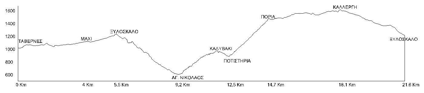
The route of the "Samaria" mountain running race moves within a radius of 4 kilometers from Xyloskalos (Northern entrance of the Samaria gorge). It starts from the taverns at the entrance of the plateau and follows for the first 4 km an alternative route through rural roads and paths to the location "Machi" (altitude 1,200 m, intersection with the rural road to the Kallergi refuge), where the first point is located supply.
From "Mahi" it continues on a slightly uphill asphalt road for one and a half (1.5) kilometers, to Xyloskalos (altitude 1,250m). Here is the second supply point.
From there we enter the path of the Samaria gorge, heading southeast. The path for the first 500 meters is quite downhill and continues gently downhill.
At 7,600 m of the race we meet the spring "Neroutsiko" (altitude 1,005 m) and at 8,380 m we meet the spring "Riza Sykias" (altitude 812 m).
Continuing on a gently downhill path, always on the main path of the Samaria Gorge, we arrive at 9,200 m of the route at the Agios Nikolaos Outpost (altitude 666 m), which is also the lowest altitude point of the route. Here is also the third supply point.
From this point, following the signs, we go outside the main path of the Samaria gorge, heading east. The path is clearly visible and uphill until the 11,070 meters of the route at Kalyvaki (Forestry Outpost, altitude 950 m.), a point with a panoramic view of the Samaria gorge. Then in a northerly direction, the path descends until the 12,500 m of the route to the fourth supply point, Potistiri (altitude 907 m). It follows a fairly uphill path in a north-easterly direction, passes through a small intermediate refueling station, the fifth one, at 13,500 meters (altitude 1,150 m) and continues up to 14,700 meters of the route, in the position of Poria (Mitato of Vigli, altitude 1,466 m .) which is the sixth supply point. From here we follow the slightly uphill rural road, heading west, up to 18,100m. of the route to the Kallergi refuge (altitude 1,600 m.), which is the seventh refueling station of the race. Then heading south we follow the downhill rural road to the eighth intermediate station at 20,500 meters (altitude 1,430 m.), to enter the final part of the race route, on a downhill path heading southwest, thus completing the circle, we reach 21,600 meters of the route at Xyloskalos (altitude 1,250 m.), where we finish.
Table of Race Supply Stations
| STATION | KILOMETERS | DISTANCE | ALTITUDE |
| TAVERNES | START | 0 | 1100m |
| OMALOS "MAHI" | 1st STATION | 4000m | 1200m |
| XYLOSKALO | 2nd STATION | 5500m | 1250m |
| AGIOS NIKOLAOS | 3rd STATION | 9200m | 666m |
| POTISTIRIA | 4th STATION | 12500m | 907m |
| Intermediate station | 5th STATION | 13500m | 1150m |
| PORIA | 6th STATION | 14700m | 1466m |
| KALLERGI | 7th STATION | 18100m | 1600m |
| Intermediate station | 8th STATION | 20500m | 1430m |
| XYLOSKALO | FINISH | 21600m | 1250m |
Power supply
The table below shows the types of food that will be offered to the competitors of the "Samaria" mountain running race, at the race's main supply stations. Each athlete can carry, on his own initiative, additional liquid or solid food of his choice, in addition to the items provided by the organization.
| STATION | KM | WATER | ISOTONIC |
| OMALOS "MAHI" | 4000m | X | |
| XYLOSKALO | 5500m | X | |
| AGIOS NIKOLAOS | 9200m | X | X |
| POTISTIRIA | 12500m | X | X |
| PORIA | 14700m | X | X |
| KALLERGI | 18100m | X | X |
Route diagram