")
Route:
The Hellenic Mountaineering Association of Chania, in its effort to give the opportunity to hikers and young athletes to have a first experience with running in the beautiful mountainous environment adjacent to the Samaria National Park, organizes alongside the "Samaria Run", for the first time, the Mountain Running Race 'OMALOS RUN' on a beautiful mountain course of 7 kilometers with beautiful pictures and views towards the Omalos Plateau and the western White Mountains, with the traffic of the taverns on the Omalos Plateau and the finish at the entrance of our National Forest.
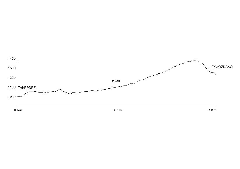
The route of the mountain running race "Omalos Run" moves in a radius of 4 kilometers from Xyloskalos (northern entrance of the Samaria gorge), starts from the taverns at the entrance of the Omalos plateau and follows for the first 4 km an alternative undulating route through rural areas. roads and paths to the site "Mahi" (altitude 1,200 m, junction with a rural road to the Kallergi refuge), where the first supply point is located, from "Mahi" continue on the uphill dirt road to the refuge for a switchback (1, 5) kilometer, to the point where the downhill path to Xyloskalos begins. Here at high 1,430 m. is the second control and supply point, from where we continue on the final part of the race route, on a downhill path in a southwest direction and finish at 7,000 meters of the route at Xyloskalos (altitude 1,250 m), where we finish.
Table of Race Supply Stations
|
STATION |
KILOMETERS |
DISTANCE |
ALTITUDE |
|
«TAVERNES» |
START |
0 m |
1100 m |
|
OMALOS «MAHI» |
1st STATION |
4.000 m |
1200 m |
|
CROSSING FOR XYLOSKALO |
2nd STATION |
5.500 m |
1430 m |
Route diagram